


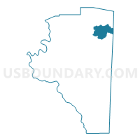
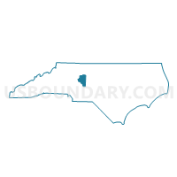
Voting District 72, Davidson County, North Carolina
About
Outline

Summary
| Unique Area Identifier | 639864 |
| Name | Voting District 72 |
| County | Davidson County |
| State | North Carolina |
| Area (square miles) | 14.65 |
| Land Area (square miles) | 14.65 |
| Water Area (square miles) | 0.00 |
| % of Land Area | 100.00 |
| % of Water Area | 0.00 |
| Latitude of the Internal Point | 35.92813190 |
| Longtitude of the Internal Point | -80.10115730 |
Maps

Graphs
Select a template below for downloading or customizing gragh for Voting District 72, Davidson County, North Carolina


Neighbors
Neighoring Voting District (by Name) Neighboring Voting District on the Map
- Voting District 02, Davidson County, NC
- Voting District 28, Randolph County, NC
- Voting District 44, Davidson County, NC
- Voting District 60, Davidson County, NC
- Voting District 64, Davidson County, NC
- Voting District 70, Davidson County, NC
- Voting District 80, Davidson County, NC
- Voting District H01, Guilford County, NC
Top 10 Neighboring County Subdivision (by Population) Neighboring County Subdivision on the Map
- High Point township, Guilford County, NC (79,032)
- Thomasville township, Davidson County, NC (39,010)
- Trinity township, Randolph County, NC (26,604)
- Abbotts Creek township, Davidson County, NC (12,846)
- Midway township, Davidson County, NC (12,181)
Top 10 Neighboring Place (by Population) Neighboring Place on the Map
Top 10 Neighboring Unified School District (by Population) Neighboring Unified School District on the Map
- Guilford County Schools, NC (488,406)
- Davidson County Schools, NC (127,662)
- Randolph County Schools, NC (113,222)
- Thomasville City Schools, NC (14,979)
Top 10 Neighboring State Legislative District Lower Chamber (by Population) Neighboring State Legislative District Lower Chamber on the Map
- State House District 61, NC (87,087)
- State House District 73, NC (82,874)
- State House District 80, NC (78,723)
- State House District 78, NC (69,360)
- State House District 81, NC (65,650)
Top 10 Neighboring State Legislative District Upper Chamber (by Population) Neighboring State Legislative District Upper Chamber on the Map
- State Senate District 33, NC (189,009)
- State Senate District 28, NC (177,037)
- State Senate District 29, NC (169,550)
Top 10 Neighboring 111th Congressional District (by Population) Neighboring 111th Congressional District on the Map
Top 10 Neighboring Census Tract (by Population) Neighboring Census Tract on the Map
- Census Tract 601.02, Davidson County, NC (7,213)
- Census Tract 605, Davidson County, NC (5,499)
- Census Tract 607, Davidson County, NC (4,915)
- Census Tract 602.01, Davidson County, NC (4,909)
- Census Tract 608, Davidson County, NC (4,538)
- Census Tract 606.01, Davidson County, NC (4,342)
- Census Tract 316.01, Randolph County, NC (3,905)
- Census Tract 606.02, Davidson County, NC (2,563)
- Census Tract 144.08, Guilford County, NC (2,326)